
Japan's reputation among skiers rests on two separate claims: that it gets an enormous amount of snow, and that the snow itself is exceptionally light and dry. Both claims are true, and both come down to the same underlying mechanism, one that's genuinely unusual on a global scale and worth understanding properly.
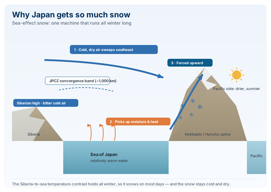
The mechanism: sea-effect snow
Every winter, an intense high-pressure system builds over Siberia, sitting above some of the coldest air on the planet. As that bitterly cold, dry continental air is drawn southeastward, it crosses the Sea of Japan, a body of water that, by comparison, is relatively mild. The temperature difference between the frigid air above and the comparatively warm sea below is large enough that the air picks up substantial moisture and heat as it crosses, the same basic mechanism that produces lake-effect snow around North America's Great Lakes, just operating over open sea rather than a lake.
When that moisture-laden air reaches Japan, specifically the mountains running down the spine of Hokkaido and the Sea of Japan side of Honshu, it's forced abruptly upward. The mountains act, in the words of Japan's own meteorological authorities, as a wall: moist air colliding with that wall rises, cools rapidly, and dumps its moisture as fine, dry, powdery snow. Because the process depends on a temperature contrast that persists for essentially the entire winter, it repeats itself day after day rather than arriving as occasional storms, which is a large part of why Japan's snow reliability is so much greater than most of the world's other major ski regions.
The JPCZ: a named, mappable phenomenon
Japanese meteorologists have a specific name for the most intense version of this process: the JPCZ, or Japan Sea Polar Air Mass Convergence Zone. When a particularly strong outbreak of Siberian cold air splits around the Korean peninsula and reconverges over the Sea of Japan, it forms a convergence zone roughly 1,000km long, visible on satellite imagery as a distinct band of cloud stretching across the sea. Snow clouds intensify rapidly along this band, and when it lines up directly with a particular stretch of coastline, that area can receive genuinely extreme, highly localised snowfall, sometimes dramatically more than areas only a short distance away that the convergence zone missed.
How much snow actually falls
The numbers involved are among the highest anywhere on Earth. Sukayu, a location in far northern Honshu, averages roughly 694.5 inches, close to 58 feet, of snowfall a year according to Japan's Meteorological Agency, making it one of the snowiest inhabited places measured anywhere on the planet. Niseko, Hokkaido's best-known international resort, has consistently recorded 10 to 15 metres of snowfall at village level over the past decade, with village-level snow depth reaching 2 to 3 metres by January and up to 4 metres by February in a typical season. Hakuba, on Honshu, averages a still-substantial 8 to 12 metres a year, slightly less than Hokkaido's totals but with excellent access from Tokyo.
Individual extreme events push well beyond even those remarkable averages. The highest 24-hour snowfall and snow depth ever measured anywhere on Earth is believed to have occurred at Japan's Mount Ibuki, where 90.6 inches, about 7.5 feet, of snow fell in a single day on 14 February 1927, at an elevation of roughly 5,000 feet, leaving a total snow depth of 465.4 inches on the ground.
Why the snow quality is so distinctive
Heavy snowfall alone doesn't explain Japan's reputation. Plenty of places get a lot of snow without producing anything like Japanese powder. The quality comes down to temperature and moisture content working together. Because the source air is genuinely frigid Siberian continental air rather than a milder maritime airmass, the snow that falls tends to have unusually low water content, commonly cited in the region of 4 to 10% depending on location, with the coldest, most inland parts of Hokkaido producing the driest snow of all. Consistently cold temperatures through the core of winter, commonly averaging around minus 8°C in resort areas like Niseko, also mean the snow that falls stays dry rather than going through the freeze-thaw cycles that turn snow heavy, crusty or icy elsewhere in the world. The combination of low moisture content at the point of formation and cold enough temperatures afterward to prevent it from changing character is what produces the famously light, "champagne powder" texture skiers travel across the world for.
Why people choose to ski there
Put those pieces together and the appeal becomes straightforward. Most of the world's major ski regions depend on individual storm systems arriving periodically, meaning a trip's success is genuinely a matter of timing and luck. Japan's sea-effect mechanism operates continuously through the core of winter as long as the Siberian-Sea of Japan temperature contrast holds, which it reliably does from December through February, so it snows on most days rather than in occasional bursts. Combined with snow quality that stays light and dry rather than deteriorating between storms, and reasonably consistent, genuinely cold temperatures that protect that quality, it's a rare combination of both volume and consistency that's difficult to find anywhere else on Earth.