
Australia's ski season runs on a narrow margin. The Alps are lower and further from the pole than almost anywhere else with a ski industry, which means the systems that bring snow have to fight harder to get here, and a swing of a degree or two at the wrong altitude is the difference between a powder weekend and a washout. Understanding a handful of things about how these systems work makes the forecast far more useful than just checking whether the icon says snow.
Where the systems come from
Most of the snow that falls on the NSW and Victorian Alps starts life a very long way south, in low pressure systems spinning in the Southern Ocean, often closer to Antarctica than to the Australian mainland. As these lows track eastward, the counter-clockwise circulation around them drags cold air and moisture up toward the southeast coast. By the time a front reaches Perisher or Hotham, it's usually the tail end of a system that was born thousands of kilometres away.
How far north those fronts get is largely governed by the Southern Annular Mode, or SAM, which describes whether the belt of strong westerly winds circling the Southern Ocean sits closer to Antarctica or further north toward the mainland. When SAM runs negative, the belt shifts north and drags cold fronts with it, and the Alps get more shots at snow. When SAM runs positive, the westerlies tighten toward the pole and a lot of those fronts miss the mainland entirely, sliding under Tasmania instead. If you follow Australian snow forecasting for more than a season, you'll hear SAM mentioned constantly, and this is why.
The 850hPa temperature, and why it matters more than the surface reading
Checking the surface temperature at a resort tells you what it feels like in the village car park. It tells you very little about whether it's actually going to snow, because the air near the ground is affected by all sorts of local warming, from sunlight to nearby terrain to whatever's happened in the previous few hours. Forecasters instead look higher up, at the temperature around 850 hectopascals, roughly 1500 metres above sea level, because that layer is a much cleaner read on the airmass moving through.
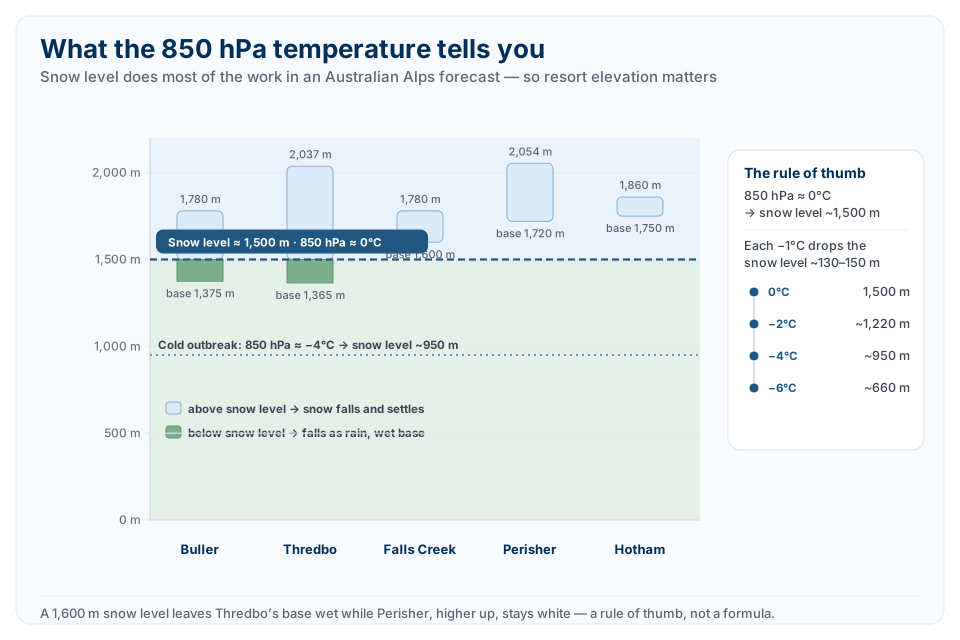
As a rough guide for the Australian Alps, an 850hPa temperature of around 0°C tends to put the snow level near 1500 metres, which is close to where a lot of the resort villages themselves sit. Get colder than that, down around minus 4 to minus 6, and the snow level drops well below the villages, opening up snow at the base rather than just the top. The relationship isn't perfectly linear, but a workable rule of thumb is that for every degree the 850hPa temperature drops, the snow level falls by somewhere around 130 to 150 metres. It's not a precise formula, since moisture, wind, and the shape of the terrain all push it around, but it's a far better starting point than the number on a phone's weather widget.
Resort elevations, and why they matter for this
Because snow level is doing most of the work in these forecasts, where a resort actually sits on the mountain matters as much as the storm itself.
In NSW, Thredbo runs from a base around 1365 metres up to about 2037 metres at its highest lifted point, giving it the biggest vertical drop of any resort in the country. Perisher's base sits higher, around 1720 metres, with the top of the resort near 2054 metres at Mount Perisher. That difference matters in marginal storms: a front that puts the snow level at 1600 metres can leave Thredbo's lower slopes wet while Perisher, sitting entirely above that line, stays fully white.
In Victoria, Falls Creek's village sits around 1600 metres with lift-served terrain up near 1780 metres. Mount Buller runs from about 1375 metres at the base to 1780 metres at its highest point. Mount Hotham's village is the highest of the lot, close to 1750 metres, with the summit above 1860 metres, which is part of why Hotham has a reputation for holding a natural base longer than resorts that sit lower.
None of these figures are perfectly agreed on between different sources. Resort elevation gets measured at different points on the mountain by different people, and it's common to see a 30 or 40 metre difference between two websites describing the same lift. The broad picture is the useful part: Thredbo has the most vertical and the lowest base, Hotham and Perisher sit highest overall, and Buller and Falls Creek land in between.
How strong the wind actually gets
Australian storms don't just bring snow, they bring wind that regularly closes lifts. Thredbo's exposed top station has recorded gusts in the 120 to 133 km/h range on several separate occasions over the past two decades, including widely reported gusts around 128 to 133 km/h during winter storms, and Mount Hotham has recorded gusts over 100 km/h in the same events. These aren't once-a-decade numbers. Most seasons produce at least one storm where the exposed upper mountain sees sustained wind well past 100 km/h, enough to put chairlifts on wind hold for hours at a time. If a forecast shows a strong front with a tight pressure gradient behind it, expect the wind, not just the snow, to shape the day.
A few storms worth knowing
Talk to anyone who's skied the Australian Alps for more than a decade and a handful of storms come up again and again.
May 2000 is the one long-time skiers still bring up as the early-season benchmark, an unusually large and unusually early blizzard that buried the mountains well before the season had properly started, weeks before most resorts would normally expect that kind of cover.
June 2014, nicknamed Snowmageddon by the time it was over, dropped more than a metre of snow across the Alps in under two weeks in a series of back-to-back cold fronts, turning a slow start to the season into one of the best Junes on record. Spencers Creek, the benchmark snow depth site near Perisher, went from 14cm to over 100cm in the space of a week.
August 2017's Blizzard of Oz, which arrived in three separate waves over the space of a month, is still one of the more talked-about spring stretches, with over a metre of snow at some resorts and a run of powder days that pushed the season well past its usual finish.
Individually none of these are the single biggest storm on record. Old-timers will point to seasons like 1964 and 1968 as genuinely bigger, with snow recorded as early as May and base depths that dwarf anything since. But May 2000, Snowmageddon and Blizzard of Oz are the three most recent events that show up in almost every conversation about big Australian snow, because they're recent enough that a lot of people skiing today were there for them.
Snow outside the resorts
The Alps get almost all the attention, but they're not the only place in southeastern Australia that sees snow. The Central Tablelands around Orange, Oberon, and the Blue Mountains sit high enough, generally above 1000 metres, to pick up occasional light snow during the coldest outbreaks, usually the same systems that are hammering the Alps a few hundred kilometres south. It's rarely enough to ski on and it doesn't last, but a genuinely cold, deep low can put a dusting on the Blue Mountains or Oberon in the same week Thredbo is getting buried. If you're watching an 850hPa chart and the cold air is pushing unusually far north, it's worth glancing at the Tablelands forecast too.