
"Flooding" gets used as one word for what are actually two quite different hazards, and the distinction matters more than it might seem. Knowing which kind of flood is coming changes how much warning you can expect, how fast the danger arrives, and what actually puts people at risk.
Flash flooding: fast, local, and often with little warning
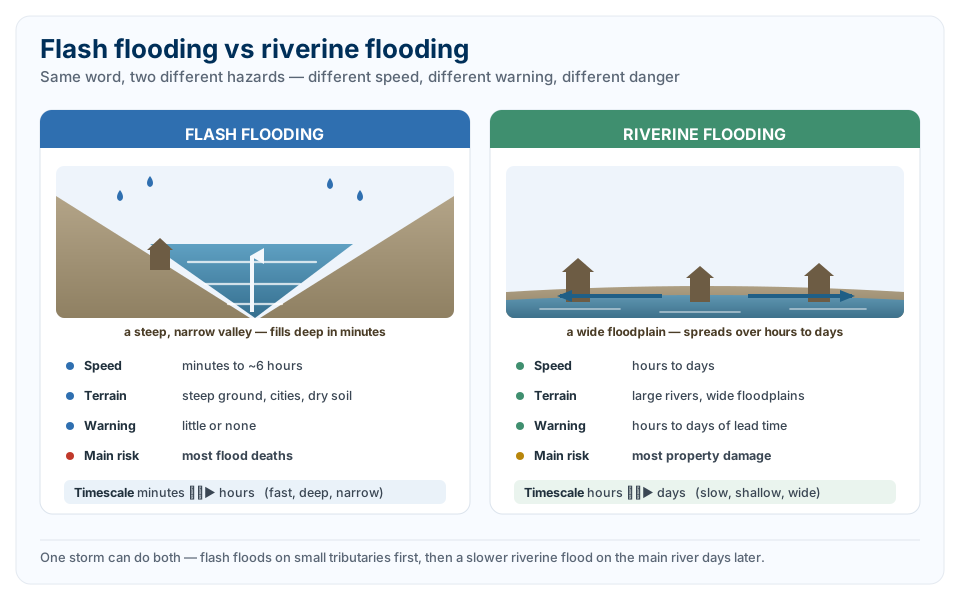
The World Meteorological Organization defines a flash flood as a flood of short duration with a relatively high peak discharge. In practice, that means water levels rising dangerously fast, generally within six hours of the rain that caused it, sometimes within minutes. Flash floods are driven by intense rainfall falling faster than the ground can absorb it or a drainage system can carry it away, and they're most dangerous in places where water has nowhere to spread out: steep terrain that concentrates runoff into narrow channels, urban streets and storm drains that funnel water quickly, or dry, rocky ground that simply can't soak anything up.
They don't always need rain falling in that exact spot, either. A flash flood can be caused by heavy rain many kilometres upstream reaching a narrow valley downstream all at once, or by a sudden release of water from a failed dam or levee, or from an ice or debris jam letting go. What defines a flash flood isn't really the cause, it's the speed: a raging torrent that can appear with little to no warning, sweep through a riverbed, urban street or mountain canyon, and be gone again within hours. That speed is exactly why flash floods are so dangerous to people: official figures attribute more loss of life to flash flooding than any other single flood type, precisely because there often isn't time to react once the water starts rising.
Riverine flooding: slower, bigger, and more predictable
Riverine, or river, flooding works on a completely different timescale. It happens when sustained or repeated rainfall, sometimes combined with snowmelt, adds more water to a river system than its channel can hold, causing the river to rise over its banks and spread across the surrounding floodplain. Because it depends on a whole catchment filling up rather than one intense burst of rain, riverine flooding typically takes hours to days to develop, and on larger rivers, it can take even longer for the flood peak to move downstream.
This slower onset is genuinely useful from a warning perspective. Where a flash flood might give residents minutes to respond, a riverine flood event often gives hours or days of lead time as authorities track rainfall in the catchment and model how the river is likely to rise. That's also why riverine floods tend to cause more property damage than flash floods overall, even though they cause fewer deaths: the water covers a much larger area for a much longer period, submerging entire floodplains rather than tearing through a single narrow channel.
Where the two overlap
The two aren't always neatly separate. A single heavy rain event can produce both: intense, localised flash flooding on smaller tributaries in the first few hours, followed by a slower riverine flood on the main river days later as all that water works its way downstream and accumulates. Some of the most damaging flood events happen exactly this way, with the flash flooding phase catching people off guard early, and the riverine flooding phase causing the more prolonged, widespread damage that follows.
Geography plays a big role in which type a given place is more prone to. Areas with steep terrain and thin or rocky soil are classic flash flood country, because there's nowhere for the water to go but downhill, fast. Flatter regions with larger, slower-moving rivers and wide floodplains are more prone to the classic riverine pattern, where the danger isn't speed but scale.
Why the distinction actually matters
Knowing which kind of flood you're dealing with changes what to actually do. A flash flood warning means the danger could already be arriving, sometimes with no visible rain falling where you are, and the right response is to move to higher ground immediately rather than wait and watch. A riverine flood warning usually comes with more lead time, and the response is more about tracking the forecast river height and knowing when your specific area is expected to be affected. Treating a fast-developing flash flood like a slow-building river flood, or vice versa, is exactly the kind of mismatch that turns a dangerous but survivable situation into a fatal one.